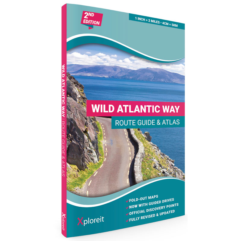
Wild Atlantic Way Route Guide & Atlas 2nd Edition (2023)
€19.99 (€19.99 ex VAT)
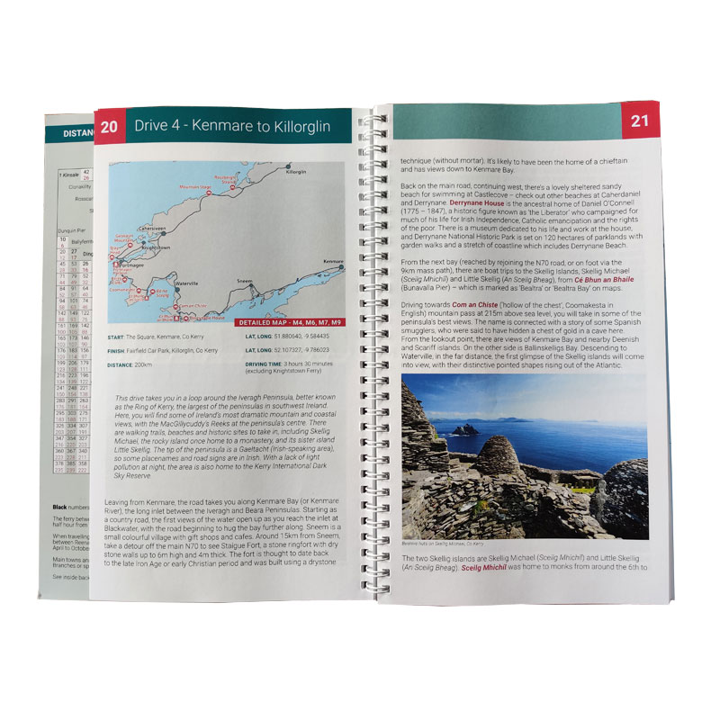
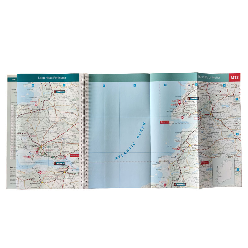
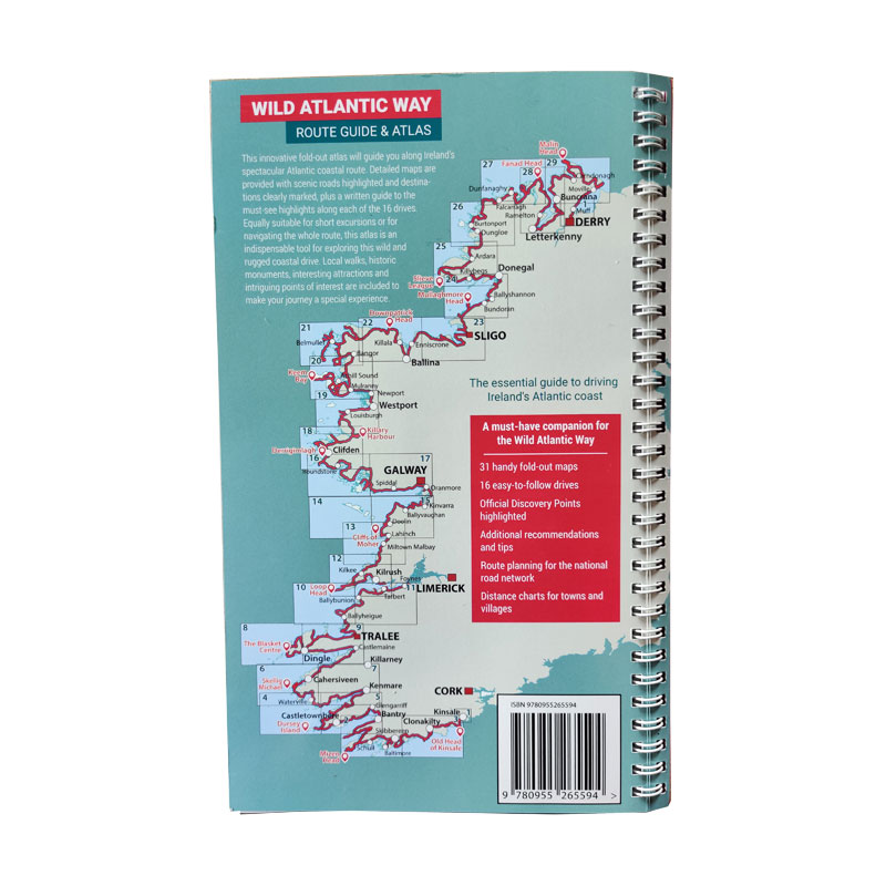
This is the 2nd Edition of Xploreit's very successful atlas of Ireland's Wild Atlantic Way and it now includes descriptive text by Irish travel writer Yvonne Gordon. The innovative fold-out atlas will guide you along Ireland’s spectacular Atlantic coastal route. Detailed maps are provided with scenic roads highlighted and destinations clearly marked, plus a written guide to the must-see highlights along each of the 16 drives. The start point for Drive 1 is Kinsale, in south Cork, while the finish point for Drive 16 is the little village of Muff in the far north of the island. Each drive can be comfortably completed in one day and includes an overview map with photographs to illustrate the text. Information is provided on mileage, directions, official discovery points and numerous additional attractions, including the many towns and villages dotted along the way. The generous fold-out maps can be used to follow the guided route or to design custom itineraries. Local walks, historic monuments, interesting attractions and intriguing points of interest are included to make your journey a special experience.
Yvonne Gordon is an award-winning travel writer who writes about Ireland for publications around the globe including the Irish Independent, The Guardian, Lonely Planet, The Washington Post, National Geographic Travel, BBC Travel and Hemispheres magazine. She is the author of Frommer’s Ireland, co-author of Back Roads Ireland and Lonely Planet Experience Ireland and her awards include Irish Travel Writer of the Year. Born and bred in Ireland, she explores the Wild Atlantic Way regularly, finding something new and fascinating on each journey.
Key Points
- 31 handy fold-out maps
- 16 easy-to-follow drives
- Official Discovery Points highlighted
- Additional recommendations and tips
- Route planning for the national road network
- Distance charts for towns and villages
Specs
- Format: Wiro Bind Fold out, Paper
- Scale: 1:126,720
- Publication Date: 15 May 2023
- ISBN: 978-0-9552655-9-4
- Category: Travel Guides, Maps & Atlases
- Dimensions: Folded Size: 16.4 x 27 cm
- Text Pages: 72 (15.4 x 27cm), colour
- Map Pages: 34 Fold out (open size 37 x 27cm), colour
- Weight: 370g
- Price: €19.99 incl. VAT (13.5%)
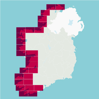
Table of Contents
|
Route Maps Overview |
2 |
|
Contents |
3 |
|
Introduction |
4 |
|
The Wild Atlantic Way |
5 |
|
Drive 1 – Kinsale to Baltimore |
8 |
|
Drive 2 – Baltimore to Bantry |
12 |
|
Drive 3 – Bantry to Kenmare |
16 |
|
Drive 4 – Kenmare to Killorglin |
20 |
|
Drive 5 – Killorglin to Tralee |
24 |
|
Drive 6 – Tralee to Killimer/Kilrush |
28 |
|
Drive 7 – Killimer/Kilrush to Doolin |
32 |
|
Drive 8 – Doolin to Galway |
36 |
|
Drive 9 – Galway to Clifden |
40 |
|
Drive 10 – Clifden to Westport |
44 |
|
Drive 11 – Westport to Belmullet |
48 |
|
Drive 12 – Belmullet to Sligo |
52 |
|
Drive 13 – Sligo to Ardara |
56 |
|
Drive 14 – Ardara to Dunfanaghy |
60 |
|
Drive 15 – Dunfanaghy to Buncrana |
64 |
|
Drive 16 – Buncrana to Muff |
68 |
|
Legend |
72 |
|
Start from Kinsale / Start from Muff |
M1 |
|
West Cork and Mizen Head |
M2 |
|
Old Head of Kinsale |
M3 |
|
Dursey Island |
M4 |
|
The Beara Peninsula |
M5 |
|
Valentia and The Skellig Islands |
M6 |
|
The Iveragh Peninsula |
M7 |
|
Slea Head and The Blasket Islands |
M8 |
|
The Dingle Peninsula |
M9 |
|
The Shannon Estuary |
M10 |
|
The River Shannon |
M11 |
|
Loop Head Peninsula |
M12 |
|
The Cliffs of Moher |
M13 |
|
The Aran Islands |
M14 |
|
The Burren |
M15 |
|
Ceantar na nOileán and Slyne Head |
M16 |
|
Galway Bay |
M17 |
|
Connemara |
M18 |
|
Clew Bay |
M19 |
|
Nephin Beg and Achill Island |
M20 |
|
The Mullet Peninsula |
M21 |
|
Downpatrick Head and Killala Bay |
M22 |
|
Sligo Bay |
M23 |
|
Donegal Bay |
M24 |
|
Slieve League |
M25 |
|
Arranmore and The Rosses |
M26 |
|
Tory Sound |
M27 |
|
Fanad Head and Lough Swilly |
M28 |
|
Malin Head |
M29 |
|
Route Planning – North |
M30 |
|
Route Planning – South |
M31 |
|
Index |
M32 |